Indonesia Table of ContentsIndonesia's variations in culture have been shaped--although not specifically determined--by centuries of complex interactions with the physical environment. Although Indonesians are now less vulnerable to the vicissitudes of nature as a result of improved technology and social programs, to some extent their social diversity has emerged from traditionally different patterns of adjustment to their physical circumstances.
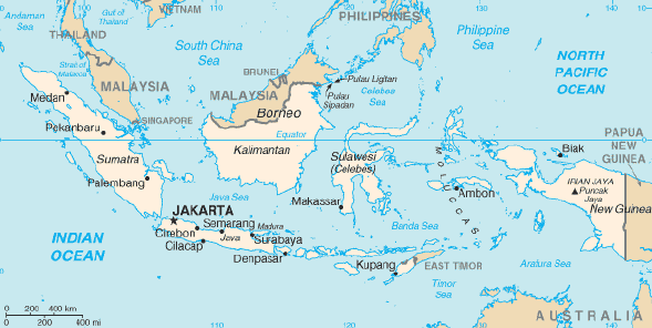
Indonesia is a huge archipelagic country extending 5,120 kilometers from east to west and 1,760 kilometers from north to south. It encompasses 13,667 islands (some sources say as many as 18,000), only 6,000 of which are inhabited. There are five main islands (Sumatra, Java, Kalimantan, Sulawesi, and Irian Jaya), two major archipelagos (Nusa Tenggara and the Maluku Islands), and sixty smaller archipelagos. Two of the islands are shared with other nations; Kalimantan (known in the colonial period as Borneo, the world's third largest island) is shared with Malaysia and Brunei, and Irian Jaya shares the island of New Guinea with Papua New Guinea. Indonesia's total land area is 1,919,317 square kilometers. Included in Indonesia's total territory is another 93,000 square kilometers of inlands seas (straits, bays, and other bodies of water). The additional surrounding sea areas bring Indonesia's generally recognized territory (land and sea) to about 5 million square kilometers. The government, however, also claims an exclusive economic zone, which brings the total to about 7.9 million square kilometers.
Geographers have conventionally grouped Sumatra, Java (and Madura), Kalimantan (formerly Borneo), and Sulawesi (formerly Celebes) in the Greater Sunda Islands. These islands, except for Sulawesi, lie on the Sunda Shelf--an extension of the Malay Peninsula and the Southeast Asian mainland. Far to the east is Irian Jaya (formerly Irian Barat or West New Guinea), which takes up the western half of the world's second largest island--New Guinea--on the Sahul Shelf. Sea depths in the Sunda and Sahul shelves average 200 meters or less. Between these two shelves lie Sulawesi, Nusa Tenggara (also known as the Lesser Sunda Islands), and the Maluku Islands (or the Moluccas), which form a second island group where the surrounding seas in some places reach 4,500 meters in depth. The term Outer Islands is used inconsistently by various writers but it is usually taken to mean those islands other than Java and Madura.
Tectonically, this region--especially Java--is highly unstable, and although the volcanic ash has resulted in fertile soils, it makes agricultural conditions unpredictable in some areas. The country has numerous mountains and some 400 volcanoes, of which approximately 100 are active. Between 1972 and 1991 alone, twentynine volcanic eruptions were recorded, mostly on Java. The most violent volcanic eruptions in modern times occurred in Indonesia. In 1815 a volcano at Gunung Tambora on the north coast of Sumbawa, Nusa Tenggara Barat Province, claimed 92,000 lives and created "the year without a summer" in various parts of the world. In 1883 Krakatau in the Sunda Strait, between Java and Sumatra, erupted and some 36,000 West Javans died from the resulting tidal wave. The sound of the explosion was reported as far away as Turkey and Japan. For almost a century following that eruption, Krakatau was quiet, until the late 1970s, when it erupted twice.
Mountains ranging between 3,000 and 3,800 meters above sea level can be found on the islands of Sumatra, Java, Bali, Lombok, Sulawesi, and Seram. The country's tallest mountains, which reach between 4,700 and 5,000 meters, are located in the Jayawijaya Mountains and the Sudirman Mountains in Irian Jaya. The highest peak, Puncak Jaya, which reaches 5,039 meters, is located in the Sudirman Mountains.
Nusa Tenggara consists of two strings of islands stretching eastward from Bali toward Irian Jaya. The inner arc of Nusa Tenggara is a continuation of the chain of mountains and volcanoes extending from Sumatra through Java, Bali, and Flores, and trailing off in the Banda Islands. The outer arc of Nusa Tenggara is a geological extension of the chain of islands west of Sumatra that includes Nias, Mentawai, and Enggano. This chain resurfaces in Nusa Tenggara in the ruggedly mountainous islands of Sumba and Timor.
The Maluku Islands (or Moluccas) are geologically among the most complex of the Indonesian islands. They are located in the northeast sector of the archipelago, bounded by the Philippines to the north, Irian Jaya to the east, and Nusa Tenggara to the south. The largest of these islands include Halmahera, Seram, and Buru, all of which rise steeply out of very deep seas. This abrupt relief pattern from sea to high mountains means that there are very few level coastal plains.
Geographers believe that the island of New Guinea, of which Irian Jaya is a part, may once have been part of the Australian continent. The breakup and tectonic action created both towering, snowcapped mountain peaks lining its central east-west spine and hot, humid alluvial plains along the coast of New Guinea. Irian Jaya's mountains range some 650 kilometers east to west, dividing the province between north and south.
Climate
Indonesia Table of ContentsThe main variable of Indonesia's climate is not temperature or air pressure, but rainfall. The almost uniformly warm waters that make up 81 percent of Indonesia's area ensure that temperatures on land remain fairly constant. Split by the equator, the archipelago is almost entirely tropical in climate, with the coastal plains averaging 28°C, the inland and mountain areas averaging 26°C, and the higher mountain regions, 23°C. The area's relative humidity ranges between 70 and 90 percent. Winds are moderate and generally predictable, with monsoons usually blowing in from the south and east in June through September and from the northwest in December through March. Typhoons and largescale storms pose little hazard to mariners in Indonesia waters; the major danger comes from swift currents in channels, such as the Lombok and Sape straits.
The extreme variations in rainfall are linked with the monsoons. Generally speaking, there is a dry season (June to September), influenced by the Australian continental air masses, and a rainy season (December to March) that is the result of mainland Asia and Pacific Ocean air masses. Local wind patterns, however, can greatly modify these general wind patterns, especially in the islands of central Maluku--Seram, Ambon, and Buru. This oscillating seasonal pattern of wind and rain is related to Indonesia's geographical location as an archipelago between two large continents. In July and August, high pressure over the Australian desert moves winds from that continent toward the northwest. As the winds reach the equator, the earth's rotation causes them to veer off their original course in a northeasterly direction toward the Southeast Asian mainland. During January and February, a corresponding high pressure system over the Asian mainland causes the pattern to reverse. The resultant monsoon is augmented by humid breezes from the Indian Ocean, producing significant amounts of rain throughout many parts of the archipelago.
Prevailing wind patterns interact with local topographic conditions to produce significant variations in rainfall throughout the archipelago. In general, western and northern parts of Indonesia experience the most precipitation, since the north- and westward-moving monsoon clouds are heavy with moisture by the time they reach these more distant regions. Western Sumatra, Java, Bali, the interiors of Kalimantan, Sulawesi, and Irian Jaya are the most predictably damp regions of Indonesia, with rainfall measuring more than 2,000 millimeters per year. In part, this moisture originates on strategically located high mountain peaks that trap damp air. The city of Bogor, near Jakarta, lays claim to having to world's highest number of rainstorms per year--322. On the other hand, the islands closest to Australia--including Nusa Tenggara and the eastern tip of Java--tend to be dry, with some areas experiencing less than 1,000 millimeters per year. To complicate the situation, some of the islands of the southern Malukus experience highly unpredictable rainfall patterns, depending on local wind currents.
Although air temperature changes little from season to season or from one region to the next, cooler temperatures prevail at higher elevations. In general, temperatures drop approximately 1° per 90 meters increase in elevation from sea level with some highaltitude interior mountain regions experiencing night frosts. The highest mountain ranges in Irian Jaya are permanently capped with snow.
Located on the equator, the archipelago experiences relatively little change in the length of daylight hours from one season to the next; the difference between the longest day and the shortest day of the year is only forty-eight minutes. The archipelago stretches across three time zones: Western Indonesian Time--seven hours in advance of Greenwich Mean Time (GMT)--includes Sumatra, Java, and eastern Kalimantan; Central Indonesian Time--eight hours head of GMT--includes western Kalimantan, Nusa Tenggara, and Sulawesi; and Eastern Indonesian Time--nine hours ahead of GMT-- includes the Malukus and Irian Jaya. The boundary between the western and central time zones--established in 1988--is a line running north between Java and Bali through the center of Kalimantan. The border between central and eastern time zones runs north from the eastern tip of Timor to the eastern tip of Sulawesi.
Environment
Indonesia Table of ContentsFor centuries, the geographical resources of the Indonesian archipelago have been exploited in ways that fall into consistent social and historical patterns. One cultural pattern consists of the formerly Indianized, rice-growing peasants in the valleys and plains of Sumatra, Java, and Bali; another cultural complex is composed of the largely Islamic coastal commercial sector; a third, more marginal sector consists of the upland forest farming communities which exist by means of subsistence swidden agriculture. To some degree, these patterns can be linked to the geographical resources themselves, with abundant shoreline, generally calm seas, and steady winds favoring the use of sailing vessels, and fertile valleys and plains--at least in the Greater Sunda Islands--permitting irrigated rice farming. The heavily forested, mountainous interior hinders overland communication by road or river, but fosters slash-and-burn agriculture.
Each of these patterns of ecological and economic adaptation experienced tremendous pressures during the 1970s and 1980s, with rising population density, soil erosion, river-bed siltation, and water pollution from agricultural pesticides and off-shore oil drilling. In the coastal commercial sector, for instance, the livelihood of fishing people and those engaged in allied activities--roughly 5.6 million people--began to be imperiled in the late 1970s by declining fish stocks brought about by the contamination of coastal waters. Fishermen in northern Java experienced marked declines in certain kinds of fish catches and by the mid-1980s saw the virtual disappearance of theterburuk fish in some areas. Effluent from fertilizer plants in Gresik in northern Java polluted ponds and killed milkfish fry and young shrimp. The pollution of the Strait of Malacca between Malaysia and Sumatra from oil leakage from the Japanese supertanker Showa Maru in January 1975 was a major environmental disaster for the fragile Sumatran coastline. The danger of supertanker accidents also increased in the heavily trafficked strait.
The coastal commercial sector suffered from environmental pressures on the mainland, as well. Soil erosion from upland deforestation exacerbated the problem of siltation downstream and into the sea. Silt deposits covered and killed once-lively coral reefs, creating mangrove thickets and making harbor access increasingly difficult, if not impossible, without massive and expensive dredging operations.
Although overfishing by Japanese and American "floating factory" fishing boats was officially restricted in Indonesia in 1982, the scarcity of fish in many formerly productive waters remained a matter of some concern in the early 1990s. As Indonesian fishermen improved their technological capacity to catch fish, they also threatened the total supply.
A different, but related, set of environmental pressures arose in the 1970s and 1980s among the rice-growing peasants living in the plains and valleys. Rising population densities and the consequent demand for arable land gave rise to serious soil erosion, deforestation because of the need for firewood, and depletion of soil nutrients. Runoff from pesticides polluted water supplies in some areas and poisoned fish ponds. Although national and local governments appeared to be aware of the problem, the need to balance environmental protection with pressing demands of a hungry population and an electorate eager for economic growth did not diminish.
Major problems faced the mountainous interior regions of Kalimantan, Sulawesi, and Sumatra. These problems included deforestation, soil erosion, massive forest fires, and even desertification resulting from intensive commercial logging--all these threatened to create environmental disaster. In 1983 some 3 million hectares of prime tropical forest worth at least US$10 billion were destroyed in a fire in Kalimantan Timur Province. The disastrous scale of this fire was made possible by the piles of dead wood left behind by the timber industry. Even discounting the calamitous effects of the fire, in the mid-1980s Indonesia's deforestation rate was the highest in Southeast Asia, at 700,000 hectares per year and possibly as much as 1 million hectares per year. Although additional deforestation came about as a result of the government-sponsored Transmigration Program (transmagrasi) in uninhabited woodlands, in some cases the effects of this process were mitigated by replacing the original forest cover with plantation trees, such as coffee, rubber, or palm. In many areas of Kalimantan, however, large sections of forest were cleared, with little or no systematic effort at reforestation. Although reforestation laws existed, they were rarely or only selectively enforced, leaving the bare land exposed to heavy rainfall, leaching, and erosion. Because commercial logging permits were granted from Jakarta, the local inhabitants of the forests had little say about land use, but in the mid-1980s, the government, through the Department of Forestry, joined with the World Bank to develop a forestry management plan. The efforts resulted in the first forest inventory since colonial times, seminal forestry research, conservation and national parks programs, and development of a master plan by the Food and Agriculture Organization (FAO) of the United Nations (UN).
National Territory
Indonesia Table of ContentsThe legal responsibility for Indonesia's environment continued to be a matter of controversy in the early 1990s. Among the continuing concerns were those expressed in 1982 during the UN Conference on the Law of the Sea. In this conference, Indonesia sought to defend its March 1980 claim to a 200-nautical-mile exclusive economic zone. Based on the doctrine of the political and security unity of archipelagic land and sea space (wawasan nusantara), the government asserted its rights to marine and geological resources within this coastal zone. In all, the area claimed the government, including the exclusive economic zone, was 7.9 million square kilometers. Indonesia also claimed as its territory all sea areas within a maritime belt of twelve nautical miles of the outer perimeter of its islands. All straits, bays, and waters within this belt were considered inland seas by the government and amounted to around 93,000 square kilometers. The Strait of Malacca--one of the most heavily traveled sea-lanes in the world--was considered by Indonesia and Malaysia to be their joint possession, and the two countries requested that other nations notify their governments before moving warships through these waters. The United States and several other nations rejected those claims, considering the strait an international waterway.
During the 1980s and early 1990s, Indonesia was involved in territorial disputes. One controversy concerned Indonesia's annexation of the former colony of Portuguese Timor as Timor Timur Province in 1976, an action which came under protest in the UN and among human rights activists.
Another dispute involved Indonesia's conflict with Australia over rights to the continental shelf off the coast of Timor. This problem was resolved in 1991 by a bilateral agreement calling for joint economic exploitation of the disputed area in the so-called "Timor Gap." Still other controversies arose regarding overflight rights in Irian Jaya (disputed with Papua New Guinea) and conflicting claims to the Spratly Islands in the South China Sea by Brunei, China, Malaysia, the Philippines, Taiwan, and Vietnam. Indonesia played the role of mediator in the Spratly Islands controversy.
Even as Indonesia extended its claim to territory, international environmental groups were pressing Jakarta to accept environmental responsibility for those territories. Indonesia was encouraged to monitor pollution in its territorial waters and take legal action to prevent the destruction of its rain forests. Since the late 1960s, the government addressed increasing environmental problems by establishing resource management programs, conducting environmental impact analyses, developing better policy enforcement, and enacting appropriate laws to give government officials proper authority. Despite these efforts, overlapping competencies among government departments and legal uncertainties about which department had what authority slowed progress made against environmental degradation. |
|
|
|